Brand Whitlock’s Macochee:Puritan Theo-Politics in the Midwest by Abe C. Ravitz (a link to the Ohio history web site)
A Public Official as A Muckraker: Brand Whitlock
A Public Official as A Muckraker: Brand Whitlock by Neil Thorburn – link to Ohio history web site.
From the Ohio History Journal
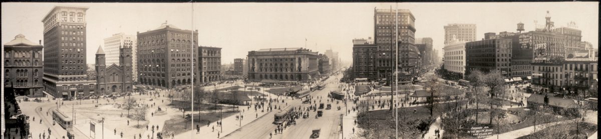
Brand Whitlock and the City Beautiful Movement
Brand Whitlock and the City Beautiful Movement by Shirley Leckie – a link to the Ohio History web site.
From the Ohio History Journal
40 years of it by Brand Whitlock
40 years of it by Brand Whitlock Google Book
A Brand for the Critics Fire or a Word for Whitlock by Winthrop Tilley
A Brand for the Critics Fire or a Word for Whitlock by Winthrop Tilley – link to a pdf on the Ohio State Historical web site
From the Ohio History Journal
“Artistic Choice” WVIZ Video about Cleveland’s Artistic Legacy
The WVIZ/PBS-produced documentary Artistic Choice tells the upbeat story of Cleveland’s artful legacy. The documentary shows a national audience that although the traditional ways of funding the arts have greatly decreased through the years, Northeast Ohioans have created an innovative way to continue to support her creative spirit and keep it alive and kicking for decades to come.
Alliance for the Great Lakes Website
The link is here
About Alliance for the Great Lakes
The Alliance for the Great Lakes is the oldest independent organization devoted 100 percent to the Great Lakes. Our professional staff works with scientists, policymakers, businesses, community groups and everyday citizens to protect and restore the world’s largest surface freshwater resource.
From forging forward-looking Great Lakes policies to promoting Great Lakes education to on-the-ground efforts to improve thousands of miles of Great Lakes shoreline, we’ve been out front and behind the scenes caring for the lakes since 1970.
“Cleveland; The Making of a City” by William Ganson Rose
“Cleveland: The Making of a City”
The complete and searchable version of the classic Cleveland history written by William Ganson Rose in 1950
From the Internet Archive
“Straddling the Color Line: Social and Political Power of African American Elites in Charleston, New Orleans, and Cleveland, 1880-1920” by Kim M. Carey, Doctoral Dissertation, 2013
“Straddling the Color Line: Social and Political Power of African American Elites in Charleston, New Orleans, and Cleveland, 1880-1920” by Kim M. Carey, Doctoral Dissertation, 2013
Kent State University
The download is here (1.6mg)