City Planning Commission adopts new plan for East Side lakefront greenway Plain Dealer April 14, 2016
The link is here

http://www.cleveland.com/architecture/index.ssf/2016/04/city_planning_commission_adopt.html

CLEVELAND, Ohio – The city’s Planning Commission on Friday voted unanimously to adopt a plan for an East Side lakefront greenway loop with new connections to neighborhoods.

Proponents characterized the plan as “unsexy” and “meat and potatoes,” but also as pragmatic and achievable.

“We wanted something that could be built in our lifetimes, or at least our work lifetimes, and not so expensive that it couldn’t be built,” said Bobbi Reichtell, executive director of Campus District Inc., one of the community development organizations that led the study.

The plan aims to improve access to a stretch of waterfront walled off from Lake Erie by the I-90 Shoreway, the lakefront railroads and Burke Lakefront Airport.

Generally, the East Side lakefront is less accessible and has less high-quality public space than the West Side, which boasts Edgewater Park.

The plan is an attempt at addressing that imbalance, and to follow up on ambitions outlined in the city’s 2004 Waterfront District Plan, but on a relatively tight budget.

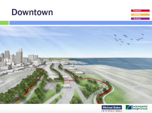
The $24.5 million plan calls for creating 8.1 miles of greenway paths along North and South Marginal roads, with connections to North Coast Harbor to the west and the lakefront marinas and Gordon Park to the east.

The Planning Commission voted unanimously to adopt the plan, making it the city’s official vision, and eligible for funding.

Likely sources of money would include federal programs that could provide cash by 2021 at the earliest, said Michelle Johnson, a director at Akron-based Environmental Design Group, which co-authored the plan with the Cleveland office of Michael Baker International, an engineering firm.

“The implementation is obviously going to be incremental,” said Freddy Collier, the city’s planning director. “The city will be working in tandem with others to explore financial possibilities wherever possible.”

A key portion of the plan depends on moving the chain-link fence on the south side of Burke Lakefront Airport three feet to the north to improve the existing Lakefront Bike Path on North Marginal Road.

Today, the path varies from 6 to 10 feet in width, but because it’s right next to the fence, the usable width is narrower, the plan said. Hydrants also exist in the middle of the path, making it dangerous.

Johnson said the plan calls for moving two 800-foot-long sections of the fence three feet to the north.

“We are very supportive of this project to identify and overcome those barriers to the development,” Pat Singleton, chief of business development and management at the city’s Division of Port Control, said about moving the fence.

She said the division, based on the newly approved plan, would apply to the Federal Aviation Administration for permission to move the fence.

Other portions of the plan call for creating a new pedestrian and bike bridge across the I-90 Shoreway to North Marginal Road at East 40th Street, plus a similar bridge from the city’s Municipal Parking Lot at East 18th Street to South Marginal Road.

The bridges alone would account for nearly half of the cost of the plan.

Developer Fred Geis, a member of the Planning Commission, said he’d like to see the greenway loop finished as a single project, instead of having the city build a collection of small segments as small pots of money become available.

He criticized the patchwork approach to completing the Cleveland section of the Towpath Trail in the Cuyahoga Valley, which intersperses completed and incomplete sections.

“It changes every year, and the street markings can’t keep up.”

He praised the new lakefront plan as “super necessary.”

“It’s an ambitious plan,” he said. “I really hope you get it done from stem to stern.”


Lake Erie aggregation
Bill Roberts

PBS Newshour 8.3.2014 about Lake Erie Algae Blooms

2 Lake Erie from Cleveland Historical

Lake Erie’s 20-Year Battle With Zebra Mussels. Article from Twineline Magazine, 2009 Winter/Spring edition published by Ohio State University

4 Lake Transportation from the Encyclopedia of Cleveland History

“Emerging Routes to Environmental Activism: Lake Erie Sportsmen and the League of Women Voters” by Terrianne Shulte D’Youville College Excursions Journal 2011

Saving Lake Erie Short Documentary from National Geographic

Environmentalism by David Beach written in 1997 for Encyclopedia of Cleveland History

8 Great Lakes Area of Concern from Wikipedia

9 Fishing Industry in Cleveland

10 Lake Erie from Wikipedia

New Lakefront Plan from Cleveland Mayor Frank Jackson Strikes a Tone of Realism – Steve Litt

New lakefront plan from Cleveland Mayor Frank Jackson strikes a tone of realism – Steve Litt, Plain Dealer November 15, 2011

The link is here

CLEVELAND, Ohio — It would be easy to greet Cleveland Mayor Frank Jackson’s new vision for the downtown Cleveland lakefront with skepticism.

After all, it’s the latest of more than half a dozen plans over the past 25 years that contemplated everything from building a floating hotel shaped like the Titanic to reconfiguring miles of shoreline with new islands made of landfill. Despite all the grand visions, the downtown lakefront remains a half-realized dream – and a chronic wasted opportunity.

Granted, a lot has been accomplished. In a burst of action starting in 1995, the city completed a collection of attractions on the shoreline, including the Rock and Roll Hall of Fame and Museum, the Great Lakes Science Center and Cleveland Browns Stadium.

But lakefront development has stalled since then, leaving the architectural icons of the 1990s standing isolated amid a barren landscape of parking lots and lifeless streets and parks.

Despite the malaise, there are good reasons to take Jackson’s new plan seriously. Most important is that it isn’t so much a cascade of wildly original ideas as it is a collection of the most logical and sensible concepts for the downtown portion of the lakefront that have surfaced in earlier plans.

This is not to suggest that the designers involved, EE&K of New York and Van Auken Akins of Cleveland, have plagiarized their predecessors.

On the contrary, the designers this time around appear to have arrived at their recommendations independently. This gives all the more credence to their conclusions, the most important of which is that there’s plenty of room for private development and ample public space on the waterfront.

In fact, the numbers sound impressive. The designers believe there’s ample space for 3.5 million square feet of development on 55 acres of waterfront land along two linear miles of shoreline that weave in and out from Dock 28 north of the stadium to the west end of Burke Lakefront Airport.

The plan also includes miles of bike paths connecting the waterfront to the downtown core and roughly two miles of public promenades on the water’s edge. Public spaces of high quality could be woven throughout three distinct waterfront zones from the Port of Cleveland to Burke.

All of this is good news, because it means the city could finally realize a greater degree of private-sector payback from the massive public investments lavished on the shoreline attractions in the ’90s.

What’s different about the new plan is that the city and the Cleveland-Cuyahoga County Port Authority have clarified the ownership and management of key parcels around the harbor, which could facilitate development.

In addition, the new plan is emerging amid a greater sense of certainty about what’s possible, and what’s not possible, on the lakefront.

The port, which had contemplated moving its downtown cargo operations east to East 55th Street, has decided to stay put on the lakefront acres west of the stadium. This settles, for now, one of the biggest questions affecting waterfront development by limiting

possibilities and allowing the city to focus first on the strong opportunities around North Coast Harbor.

Also, Jackson has come down firmly against the idea of closing Burke Lakefront Airport and either turning it into a park or a vast real estate development.

That position also makes sense. With millions of square feet of vacant office space in the core of downtown, it doesn’t seem like the best time to open up a huge new area for development along the lakefront at Burke.

It makes more sense, instead, to capitalize on the investments already made in the ’90s, such as the Rock Hall.

In many ways, Jackson’s plan represents a continuation of the ambitious lakefront plan completed in 2005 by his predecessor, Jane Campbell.

But while the Campbell plan provided an important framework for future decision-making about all nine miles of city lakefront, it was less specific about how to get things started in discrete locations.

Under the new plan, Jackson has a more plausible road map about how to get started and keep moving on the downtown waterfront.

Small but important pieces of the new vision have a decent chance of happening within three to five years, either because the projects are already funded with federal money or could attract private investment.

These include a pedestrian bridge at North Coast Harbor designed by Boston architect Miguel Rosales (another legacy of the Campbell plan), a pair of waterfront restaurants, more on-street parking on the East Ninth Street Pier and a marina for pleasure boats north of the Rock Hall.

If those elements come into being relatively soon, the city could create a sense of forward motion around the Rock Hall, which could attract bigger pieces of proposed development, such as office complexes proposed for chunks of land west and east of North Coast Harbor.

To be sure, obstacles exist. One is that the city simply doesn’t have tens of millions of dollars to pour into the infrastructure needed to trigger large-scale development on the

waterfront. It’s counting on the federal government for an $80 million grant to pay for transportation improvements at the port and for a pedestrian bridge from the north end of Mall C to North Coast Harbor and the Rock Hall.

Chris Warren, Jackson’s chief of regional development, described the process of winning such a grant as “enormously competitive,” which sounds daunting.

But other parts of the plan sound eminently doable, such as creating new parking spaces on the East Ninth Street Pier as a way to make the area more accessible on a casual basis and more like a regular city street.

The computer graphics created by EE&K and Van Auken Akins for Jackson’s lakefront plan look deceptively smooth and polished. The reality is that the plan will take two decades or more to complete and will undoubtedly evolve over time. New plans will probably emerge as the city’s circumstances change.

For now, Jackson’s plan provides a good framework for steps the city can take in the near term. It’s crucial that the mayor and his team deliver on what they’ve envisioned. If they can’t, the city’s lakefront will continue to stay frozen, largely as it was at beginning of the last decade.

Mayor Frank Jackson Tries to Change History with Lakefront Plan – Plain Dealer

Mayor Frank Jackson tries to change history with lakefront plan – Plain Dealer November 15, 2011

The link is here

port-authority-lakefront-plans-looking-west.JPG
Cleveland’s lakefront is getting new attention from Mayor Frank Jackson.

CLEVELAND, Ohio — The development of Cleveland’s lakefront is a century-old story of piecemeal action and broken promises, but Mayor Frank Jackson thinks he has strategy that could put all that in the past.

Jackson presented a plan(pdf) Monday for developing the downtown waterfront from the Port of Cleveland to Burke Lakefront Airport. Drawings show 90 acres laced with offices, restaurants, shops and marinas. (Read the earlier version of this story.)

The plan, drafted by EE&K architects of New York and Van Auken Akins Architects of Cleveland, could unfold over many years and eventually reach $2 billion in value. Most of the money is expected to come from the private sector.

Skepticism came quickly at the City Hall news conference, not only from reporters but from John Onacila, a 67-year-old boater who lives on the city’s West Side. From the rear of the room, he listened as proponents declared this plan to be The One.

“I’ve heard that before,” Onacila whispered.

But Jackson and others say the latest vision can become reality because it has the backing of the Cleveland-Cuyahoga County Port Authority, the Cleveland Browns and other lakefront interests and answers two lingering questions.

Will the port move? Will the airport close? In both cases the answer is no.

Another key is a series of ordinances, given to the council Monday night, that make clear which sections of the development area the city will control, and which will be managed by the Browns or the port authority.

Council President Martin J. Sweeney said the council should pass the legislation by February. He and downtown Councilman Joe Cimperman said they are excited about seeing mixed-use waterfront development become a reality.

“I think it’s a real shot at making something happen,” Cimperman said. “There’s going to be such a demand for this.”

The city, which owns all of the development area, will lease land to developers, just as it does with the Browns. Chris Warren, Jackson’s chief of regional development, expects some developers to commit to projects within six months, though financing and other hurdles could push construction out two or three years.

A marina for temporary docking and a pedestrian bridge over North Coast Harbor, paid for by the city with grants, will open in 2013. Warren says those projects prove Jackson’s plan is not “pie-in-the-sky.”

When other publicly financed features will arrive is not as certain. The city needs $100 million for other work, including a second pedestrian bridge linking the lakefront to downtown. Cleveland has asked the federal government to pay $80 million of that expense.

Skeptics can be forgiven. A number of grand plans for the lakefront have been floated over the years; Jackson’s is just the latest.

A 1959 plan called for a recreation center with a sports arena and aquarium. In the 1960s and 1970s, proponents pushed for an international jetport five miles offshore, along with new parks, beaches and marinas.

In 2000, then-Mayor Michael R. White proposed a $750 million plan that included a Ferris wheel, children’s museum, band shell, theater complex, aquarium, ferry dock and marina for pleasure boats.

Four years later, his successor, Jane Campbell called for five marinas, five beaches, 3.9 million square feet of office and commercial space and 7,500 housing units. Planners also spoke about building an 18-hole golf course and turning Burke Lakefront Airport into mixed-use development.

Follow Thomas Ott on Twitter @thomasott1

Teaching Cleveland Digital