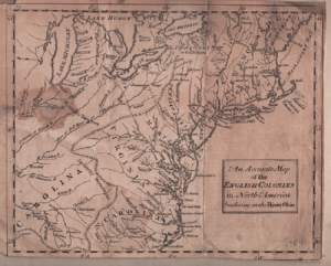
 (Map of English Colonies Bordering on Ohio River 175
The Consequences of Cleaveland
by Dr. John Grabowski, PhD | WRHS Krieger Mueller Historian
On July 4th 1796, on the bank of what is now Conneaut Creek, a group of surveyors led by Moses Cleaveland celebrated Independence Day. Naming the site Port Independence, they fired off a salute, ate a meal of pork and beans, and drank to six patriotic toasts. Eighteen days later they arrived at the mouth of Cuyahoga River, climbing up a hill on the east bank (near what is now St. Clair Avenue) to the heights over the river valley.
The river marked the boundary of that part of the Western Reserve to which Native Americans had ceded their claims in the Greenville Treaty of 1795, and it seemed a likely area to begin the exploration and mapping out of the lands now “available” to settlement. Yet it took several weeks for Moses Cleaveland to decide if the site would serve as the center for the survey party’s work, and what some might call the capital of the Western Reserve. He made that decision in August. It was the best possible choice and considered naming the settlement Cuyahoga, but his colleagues convinced him that it should take his name.
This is a quick and far too easy summary of the founding of Cleveland for it misses the broader impact of the event. When Cleaveland’s surveying crew began to lay out the lines that would define the townships of the Western Reserve, they were imposing a change on the landscape that exceeded anything that had come before.